
MareAhora
Las mareas, las olas y el viento de cualquier playa o puerto, en una sola pantalla y hora a hora.
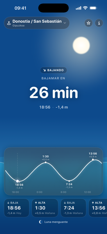
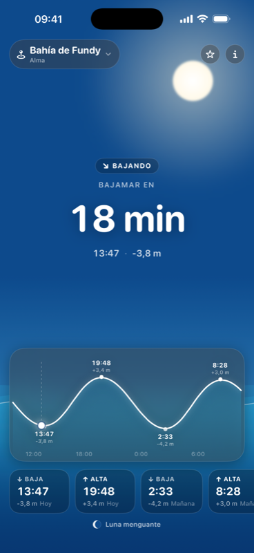
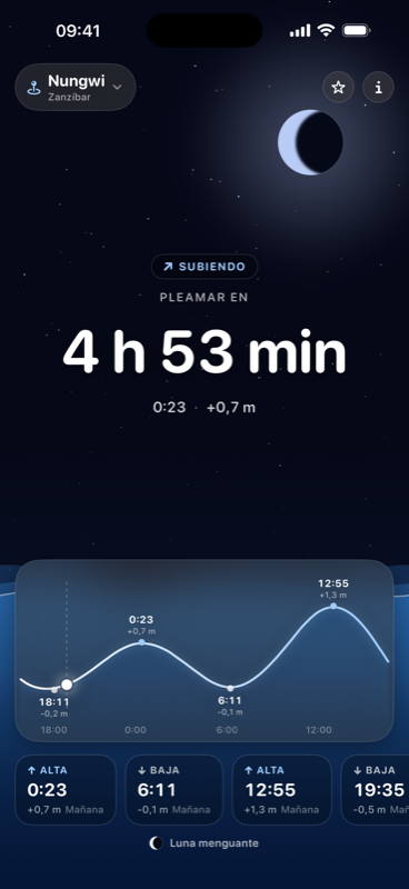
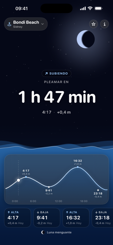
Abres la app y ves cuánto falta para la próxima marea, si el agua sube o baja y cómo va el día entero: olas, viento, corriente y temperatura del agua. Buscas una playa, un puerto o un pueblo, marcas con una estrella los que repites, pones un aviso antes de la pleamar y te llevas la cuenta atrás a la pantalla de bloqueo.
Qué hace
- La cuenta atrás hasta la próxima pleamar o bajamar, con la curva del día entera: arrastras el dedo y lees la altura del agua a cualquier hora.
- Cómo está el mar, hora a hora: olas y mar de fondo con su periodo, corriente, temperatura del agua, viento y rachas, índice UV, temperatura del aire y probabilidad de lluvia.
- Cada lectura en la escala de la gente del mar — Douglas, Beaufort, el índice UV de la OMS —, así que ves en qué peldaño estás y qué significa.
- El veredicto del día para bañarse, surfear, pescar o ir a las rocas, con su mejor franja horaria y la lectura que lo frena.
- Quince días por delante con el coeficiente de cada uno, para dar con la marea viva que buscas, y las horas solunares de pesca.
- Avisos antes de la marea con 15, 30, 60 o 120 minutos de antelación, y la cuenta atrás en la pantalla de bloqueo y en la Isla Dinámica.
- Widgets de inicio y de bloqueo, cada uno fijado al lugar que quieras o al último que miraste.
- Un buscador de cualquier sitio de costa — playas, puertos y pueblos —, con favoritos y recientes compartidos entre la app y el widget.
- Alturas desde el nivel medio del mar o desde el cero de las cartas, y el viento en km/h, mph o nudos.
- Sol y luna calculados en el propio iPhone, sin conexión y con la hora del lugar que estás mirando.
- Funciona sin cobertura: guarda la última previsión y la enseña marcada como sin conexión.
Qué sale de tu iPhone
MareAhora no tiene cuentas. Para enseñarte el mar necesita preguntar a dos servicios, y esto es todo lo que les llega:
| Qué | A quién, y para qué |
|---|---|
| Coordenadas redondeadas a ~1 km | Open-Meteo, para pedir la previsión de marea, oleaje y tiempo de ese punto. Sin clave y sin identificador tuyo. |
| Lo que escribes en el buscador | Apple (MapKit), para autocompletar el nombre del sitio. La búsqueda es mundial: tu ubicación no viaja con el texto. |
| Tu ubicación, si la das | Apple (MapKit), para ponerle nombre a tu localidad en la cabecera. Es opcional: sin ella, buscas por nombre y todo funciona igual. |
MareAhora no tiene servidores. No hay un backend mío en medio, ni base de datos, ni analítica, ni publicidad, ni ningún SDK de terceros: solo frameworks de Apple. Los favoritos, los avisos y la última previsión se quedan en tu iPhone, y los avisos se programan dentro del teléfono, sin push.
La política de privacidad lo detalla todo, permiso por permiso.
No sirve para navegar
La previsión sale de modelos globales de Open-Meteo (licencia CC BY 4.0). Van muy bien para saber si habrá playa y cómo estará el agua, pero no sustituyen a las tablas oficiales de una autoridad portuaria ni al parte oficial, y los veredictos no son un aviso de seguridad. En rías, bahías cerradas y calas del Mediterráneo con rangos de centímetros, el punto modelado más cercano puede portarse distinto que tu sitio. Antes de meterte, mira las banderas y al socorrista.
Descárgala
MareAhora es para iPhone y iPad con iOS 18.6 o posterior, en español y en inglés. Gratis, sin publicidad y sin compras dentro de la app.
Próximamente en la App Store
Preguntas
Soporte, fallos y dudas de privacidad van a hola@nachodivasson.com. También hay una página de soporte con lo que más se pregunta.
Tides, waves and wind for any beach or harbour, on one screen and hour by hour. Open it and you see how long until the next tide, whether the water is rising or falling, and how the whole day looks. Search a beach, a harbour or a town, star the ones you keep coming back to, set an alert before high water and put the countdown on your Lock Screen.
What it does
- The countdown to the next high or low water, with the full day's curve: drag a finger across it and read the water level at any hour.
- How the sea is, hour by hour: waves and swell with its period, current, water temperature, wind and gusts, UV index, air temperature and chance of rain.
- Every reading on the scale people at sea already use — Douglas, Beaufort, the WHO UV index — so you see which rung you are on and what it means.
- The day's verdict for swimming, surfing, fishing or the rocks, with the best hours and the reading holding it back.
- Fifteen days ahead with each day's coefficient, to find the spring tide you are after, plus solunar fishing windows.
- Alerts before the tide, 15, 30, 60 or 120 minutes ahead, and the countdown on your Lock Screen and in the Dynamic Island.
- Home Screen and Lock Screen widgets, each pinned to a place of its own or to the last place you looked at.
- Search any coastal place by name, with favourites and recents shared between the app and the widget.
- Heights from mean sea level or chart datum, and wind in km/h, mph or knots.
- Sun and moon computed on the device, offline, on the local time of the place you are looking at.
- Works with no signal: the last forecast is kept and shown with an offline marker.
What leaves your iPhone
| What | To whom, and why |
|---|---|
| Coordinates rounded to ~1 km | Open-Meteo, to fetch the tide, wave and weather forecast for that point. No key and no identifier of yours. |
| What you type in search | Apple (MapKit), to autocomplete place names. The search is worldwide, so your location doesn't travel with the text. |
| Your location, if you allow it | Apple (MapKit), to name your town in the header. Optional: without it you search by name and everything works the same. |
MareAhora has no servers. No backend of mine, no database, no analytics, no advertising and no third-party SDK — Apple frameworks only. Favourites, alerts and the last forecast stay on your iPhone, and alerts are scheduled on the phone itself, with no push.
The privacy policy covers it in full, permission by permission.
Not for navigation
Forecasts come from global models by Open-Meteo (CC BY 4.0). They are good for knowing whether there will be a beach and what the water is doing, but they are no substitute for a port authority's official tables or the official forecast, and the verdicts are not a safety advisory. Check the flags and the lifeguard before you go in.
Get it
For iPhone and iPad on iOS 18.6 or later, in Spanish and English. Free, no ads, no in-app purchases.
Questions
Support, bug reports and privacy questions all go to hola@nachodivasson.com. There's also a support page covering what people ask most.